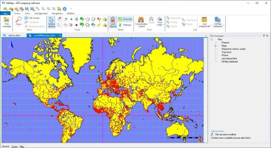
OkMap为您准确提供矢量和光栅地图和不同类型的地图投影.创建自己的数字地图,多点,折线图和多边形向量.地图同时显示矢量数据的栅格.基于矢量数据的进口数字地图的不同类型的预测.利用矢量数据校验地图导航的背景.为您去户外活动:长途跋涉在道路山地车帆船打猎和钓鱼提供帮助.
File Size: 405.7 MB
OkMap is an interactive software which allows you to work on your computer screen with web maps or digital maps that you have either bought or scanned. OkMap can also import vectorial data from the most common formats and DEM data relevant to height information. Through these maps, you can organize your paths by creating waypoints, routes and tracks on your computer monitor, and upload this data to your GPS. OkMap sets automatically altitude data and estimates travel times.
Features
Calibration / display raster maps (over 30 image formats)
Display vectorial maps
Display hybrid maps (raster + vectorial data)
Ability to open multiple maps simultaneously
9 cartographic projections of the most used
Database with over 500 predefined projections by geographic area
Database with over 300 datum
Viewing 3D raster maps on Google Earth (for supported image formats)
Map add-ons management (icons, comments)
Vectorial data management (point, multipoint, line, polygon)
GPX data management (waypoints, tracks, routes)
Selecting multiple objects with the mouse
Context menu (right mouse)
Auto-info function
Zoom, autofit functions
Moving map function in 3 modes
Customizing toolbar
Showing yes / no toolbar
Showing yes / no statusbar
Check new releases at startup
Homepage
https://anonymz.com/…//www.okmap.org
Download rapidgator
https://rg.to/file/7f5fd8d985558b706ca49a535e8d15e7/OkMap.17.rar.html
Download nitroflare
https://nitroflare.com/view/2C4AA236ECB59B8/OkMap.17.rar
Download 百度网盘
链接: https://pan.baidu.com/s/1uAmx2ysUa4ZaB6p-YppcwA?pwd=uqyq 提取码: uqyq