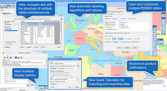
MapInfo Professional是由MapInfo公司出品的一款桌面地图制图系统。MapInfo Professional可以在一张地图上合并和显示不同格式和投影的地图数据。
MapInfo Professional 是一款功能强大、用户界面友好的商业绘图及分析工具,包含令人耳目一新的用户界面、访问开源数据库PostGIS的权限以及内置的对于 Layered PDF生成的支持。这款极具成本效益的解决方案,将帮助企业在库存管理、资源配置、客户沟通的决策制定的过程中从数据中获得最大的价值。
MapInfo Professional 优势包括:
• 更加出色的易用性——提供了一个更加直观的用户界面,通过Layered PDF实现数据共享,使企业能够更加方便、高效地创建和分享自定义地图,有利于提高效率、节省时间。
• 大量的成本节省——MapInfo Professional 支持开源数据库PostGIS,为用户提供了具有成本效益以及开源的选择。
• 增强的数据存取——企业可以利用包括Microsoft SQL Server® 2008在内更多的数据,获得更加充分的灵活性,并可持续访问多种类型的数据。
“对我们而言,MapInfo Professional 的推出是一个重要的里程碑。PBBI公司致力于帮助企业在制定关键的商业决策时能从数据中获得最大的价值。我们征求了数以万计客户的意见,以确保 MapInfo Professional 能够最大限度地满足客户的需求。”PBBI公司总裁Michael Hickey表示。“在当今充满挑战的经济环境中,企业迫切需要利用工具制定资源配置、库存管理、客户协调等方面的决策。MapInfo Professional提供了一种具有成本效益、易于使用的解决方案,有利于企业制定前瞻性的商业决策,提升核心竞争力。”
Pitney Bowes MapInfo Professional 12.5.0.33 (x86/x64) | 466/403 MB
MapInfo Professional is a powerful mapping and geographic analysis application. By visualising the relationships between data and geography, MapInfo Professional makes it fast and easy to create, share and use maps by turning data into information.
See your data in a bold new way with MapInfo Professional, a powerful mapping and geographic analysis application. MapInfo Professional enables you to examine and demonstrate the relationship between geography and data thanks to its powerful analytical and geoprocessing tools.
MapInfo Professional v12.0 is here!
MapInfo Professional v12.0 brings major improvements to creating high quality cartographic output with improvements to the labelling, Legend Designer, Layout Window, scale bars and more.
Other improvements include support for Windows 8, SQLite and PostGis v2.0, improved import/export capabilities, tools for converting linework to regions, many ease of use enhancements and lots more!
Simple to use and integrate
MapInfo Professional is extremely flexible and can be easily integrated with your current IT systems. It is also extremely user-friendly so you don’t need to be an IT expert to use it.
Easily accessible data
MapInfo Professional supports a range of data formats including many common PC file formats (such as Microsoft Excel, Access, DBF and CSV files), relational and spatial database formats (Oracle, Microsoft SQL Server, PostGIS, SQLite and ODBC compliant databases), and spatial data formats ( AutoCAD DXF/DWG, SHP, DGN and more).
You can also use imagery (aerial images, satellite images, scanned paper maps, etc.) of almost any format in your maps. And MapInfo Professional includes access to Microsoft Bing aerial and hybrid maps as standard.
Superb data creation and editing functions
With MapInfo Professional you can access a vast selection of CAD data creation and editing tools as well as edit tabular data like values and names.
MapInfo Professional allows you to make changes to all your maps and data in a single application, saving you time and effort.
Flexible map display and visualisation options
MapInfo Professional’s simple-to-use map display wizards and detailed customisation options allow users of all skill levels to create great looking maps quickly. Load image data sets as background mapping and overlay your point, line and polygon data to visualise your data in the way you want. Change the style and appearance of any data set using our powerful analytical processes and display customisation techniques.
You can also aggregate values using statistical or any math functions to associate a symbol or colour to a point or a region based on a calculated value. For example, view your sales territories according to the number of customers in each area.
Share your results
MapInfo Professional makes communicating your results easy, thanks to its wide range of data sharing and publishing options.
Print or publish maps of any size with legends and charts through simple-to-use wizards so you can share your results with everyone you need to. For sharing data you can save or export it to many commonly used formats.
A complete suite to meet your needs
MapInfo Professional is part of the MapInfo GIS Suite, a comprehensive set of integrated offerings including desktop, server, web and data products. As your requirements grow, your MapInfo solution has the power to grow with you.
Home Page – http://www.mapinfo.com/
Download uploaded
http://uploaded.net/file/ml74puxg/Pitney.Bowes.MapInfo.Professional.v12.5.0.122.x64-BEAN.part1.rar
http://uploaded.net/file/a6a3jjeb/Pitney.Bowes.MapInfo.Professional.v12.5.0.122.x64-BEAN.part2.rar
http://uploaded.net/file/kseq3kkb/Pitney.Bowes.MapInfo.Professional.v12.5.0.33-BEAN.part1.rar
http://uploaded.net/file/mjnggos8/Pitney.Bowes.MapInfo.Professional.v12.5.0.33-BEAN.part2.rar
Download rapidgator
http://rg.to/file/9bc5424cf95007e84f28f5f36e076724/Pitney.Bowes.MapInfo.Professional.v12.5.0.122.x64-BEAN.part1.rar.html
http://rg.to/file/2f30e1c5abeaceb6881da5c6689e76c8/Pitney.Bowes.MapInfo.Professional.v12.5.0.122.x64-BEAN.part2.rar.html
http://rg.to/file/f0bf497f17b091d520b8c9a284e04755/Pitney.Bowes.MapInfo.Professional.v12.5.0.33-BEAN.part1.rar.html
http://rg.to/file/916c76f2c1f732465d9780dd69bd79c7/Pitney.Bowes.MapInfo.Professional.v12.5.0.33-BEAN.part2.rar.html
Download 城通网盘
Pitney.Bowes.MapInfo.Professional.v12.5.0.122.x64-BEAN.part1.rar: http://www.t00y.com/file/79657953
Pitney.Bowes.MapInfo.Professional.v12.5.0.122.x64-BEAN.part2.rar: http://www.t00y.com/file/79618832
Pitney.Bowes.MapInfo.Professional.v12.5.0.33-BEAN.part1.rar: http://www.t00y.com/file/79657954
Pitney.Bowes.MapInfo.Professional.v12.5.0.33-BEAN.part2.rar: http://www.t00y.com/file/79657955
Download 百度云
你是VIP 1个月(1 month)赞助会员,
转载请注明:0daytown » Pitney Bowes MapInfo Professional 12.5.0.33 (x86/x64)